This blog post shows how snippets from the route manager plugin can be placed inside a blog post or any other WordPress article page using shortcodes.
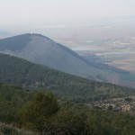
According to the Old Testament, Mt. Gilboa is a place of tragedy and triumph. Israelis flock here every year from February to April to see the multitude of wildflowers and the famed purplish Gilboa Iris. it is also a great mountain range overlooking the Jezreel Valley in northern Israel.
In the Old Testament, Samuel I 38:8, it was here that Saul, the first King of Israel and his sons died fighting the Philistines, “And it came to pass on the morrow, when the Philistines came to strip the slain, that they found Saul and his three sons fallen in mount Gilboa”. So there is quite a bit of history related to hiking the Gilboa mountains.
Bet hashita - Gilboa
- Distance 9612 m
- Duration 2 h 23 min
- AVG speed 4.0 km/h
- Min altitude -84 m
- Peak 246 m
- Climb 422 m
- Descent 403 m
Our trip started at Beit HaShita which is an Israeli kibbutz situated between Afula and Beit She’an. It was founded in 1935. There are currently 273 kibbutzim in Israel. Most of them like Beit HaShita are located in peripheral areas. Beit Hashita is a small Kibbutz with 1089 members working according to the Renewed Kibbutz model which means each member receives a regular salary from work and other income sources specific to each individual member. The kibbutz retains joint ownership of the kibbutz instruments of production and other assets, along with a “safety net” for health insurance, pension, education and supporting members with special needs.
From Beit HaShita, we crossed the Jezreel Valley fields and the fish farming areas leftover from the traditional main farming method used in the Jezreel Valley for many years. This method is slowly disappearing due to the economic cost related to cost of water and breeding. The route trail is shown below.
Bet hashita - Gilboa


The walk started at sea level, but crossing the Jezreel Valley fields took us below sea level as shown in this graph. While climbing up the mountain, we again go above sea level. All together the altitude gain is 422 meters.
The route overall length is 10km and the overall altitude gain is 422 meters, which makes this hike a moderate one. While the lowest point is 84 meters below sea level, the Gilboa mountain peak reached in this trip makes this hike quite moderate.
Bet hashita - Gilboa
- Distance 9612 m
- Duration 2 h 23 min
- AVG speed 4.0 km/h
- Min altitude -84 m
- Peak 246 m
- Climb 422 m
- Descent 403 m
- Distance Instructions
We have prepared detailed trail information shown in this link.
You can also see other near by routes in northern Israel